

Preparing for Hurricane Dorian
Date
Thursday, August 29, 2019
Date
Thursday, August 29, 2019
 For those of you who have not heard the latest update, Hurricane Dorian is set to impact Florida’s east coast this long Labor Day Weekend or early next week as a Category 4 storm.
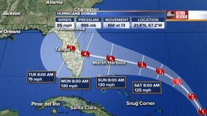
The most recent wind strength forecast as part of the National Hurricane Center’s 11 a.m. Thursday advisory says Dorian’s peak winds are expected to reach 130 mph — the minimum strength for an intense Category 4 hurricane.
The predicted storm track still has Dorian heading generally toward Central Florida, though a number of factors will dictate its ultimate track including a high pressure system to the east. The high pressure system’s strength — or lack of it — will be a significant factor in pushing Dorian to the north or south.
Because of these as yet unpredictable factors, the window of impact, or “cone of uncertainty, is a swath more than 400 miles wide and extends from the Florida Keys to southern Georgia.
Florida residents who were here for Hurricane Matthew in 2016 and Hurricane Irma in 2017 will remember that almost right up until the last day or so, nobody really knew if Florida would be spared or not.
And Irma, which made landfall as a Category 4 hurricane with winds of 132 mph in Cudjoe Key in the lower Keys, still exacted damage in Miami-Dade, Broward and Palm Beach counties.
The point is, Floridians should prepare themselves for Hurricane Dorian as best as possible while we wait to see further developments.
We, at Joe Taylor Restoration, are doing just that. We are making sure we are ready to serve all of those impacted, should Hurricane Dorian come ashore anywhere in our coverage area. We continue to hope that this storm turns and heads out to sea. However, if it does not, and you find yourself faced with flooding or water damage of any kind, don’t hesitate to contact us. We are here to help!